Water

-

Old Lake - Tata

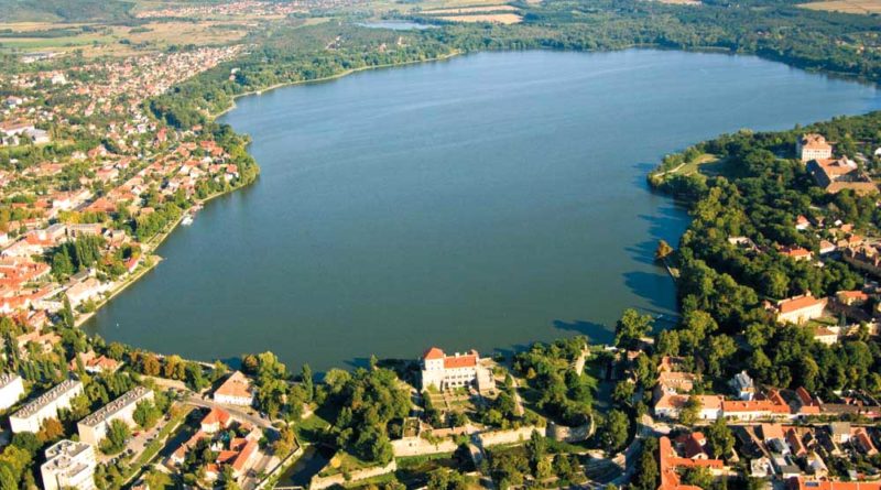
Tata is called the "city of waters", because the area was abundant in crystal clear springs. The best known of its standing waters is the Old Lake. Its formation is due to the terrain and the nearby springs. The waters running off the surrounding hills and hilly countryside, as well as the ground waters, have gathered in this lower area and have grown into lakes. This is how the landscape characterized by reeds and marshes was formed, whose water balance was already regulated by the construction of a valley dam in the Roman era. The Old Lake of Tata is Hungary's oldest fishing lake. With its 220 hectares is considered to be the largest standing water of the Central Transdanubian region beside Lake Balaton and Lake Velence. The oldest fishing lake in Hungary, as the valley dam including the building complex of Tata Castle was built more than 600 years ago in the 14th century. The Old Lake is listed in the Ramsar Convention for the Protection of Wetlands of International Importance. The importance of international nature conservation is due to the fact that it is one of the most important gathering places in Europe for the wild geese. In addition to the medieval castle on its shore, there are many historic buildings, which makes it one of the most exquisite lakes in Hungary.

Mouth of the Concó Stream at the Danube – Ács


Flowing from its source in the Bakony Hills, the Concó Stream reaches the Danube at Ács. Long ago somewhere near its mouth the Romans established a camp, which is believed to have been set up around the same time as the legionary camp of Brigetio in Ószőny. Some of its remains are still underground, while the rest have been washed away by the floods of the stream – or rather of the Danube by now. Gold panning has significant traditions along this gravelled bank of the river. It is an activity with a past of several thousand years in the Carpathian Basin and the technique has hardly changed over time. While gold panning occupied thousands of people a few centuries ago, around 1940 only a few panned gold along the Danube, the Dráva and the Mura. Today gold panners at work along the bank can only occasionally be seen. Depending on the water-level, the Danube mouth of the Concó always looks different. It sometimes dries out completely and then you can walk along the pebble banks. At other times you can sail in a small watercraft up to a certain point.

Saint Paul’s Island - Komárom – Koppánymonostor


Saint Paul’s Island in the Koppánymonostor district of Komárom has remained to represent the formerly romantic archipelago of the Danube with washland alluvial forests of willows and poplars, orchards and extensive meadows. Eight bank-filtered wells drilled here provide drinking water for the towns of Komárom and Ács. During the Middle Ages, this part of the Danube used to be an excellent spot for fishing, providing an ideal place for catching sturgeon swimming up from the Black Sea. In addition, the ancient craft of gold panning was practised along this and the Ács bank of the river for a long time. The last gold panner gave up this exhausting and uneconomic work along the Danube in the 1970s. The film adaptation of Mór Jókai’s novel The Man with the Golden Touch was shot here. When you walk to the main branch of the river, you must watch out because the ground can suddenly disappear from under your feet. The Danube considerably bit into the bank and formed an inlet-like cavity in the loose sediment. The building-destroying impact of the river never ceases and thus an ever-changing vista can be seen when you walk this way.

Danube bank – Almásfüzitő

Almásfüzitő received its present name in 1895. It was the Hungarian State Railways which in effect provided its name when it established a joint railway station under this name for the villages of Almás and Füzitőpuszta. The village, which was primarily known for its industrial past, today boasts of a significant tourist attraction, namely the assembly of buildings of Azaum Roman Camp, which was established to conserve and present the Roman past of the village. The historical theme park aims to revive Roman traditions and provide true-to-life experiences through events. Its latest exhibition space is an interactive adventure unit where the most up-to-date technical tools (VR – virtual reality and AR – augmented reality) bring the world of that past closer. In addition, copies of former articles of everyday use can be touched. Leaving the camp behind, you reach the rampart and the bank of the Danube. A boat house and a rest house welcome visitors. When you look around from here you can see the relaxing current of the large river and the boats moving on the surface of the water.

Danube promenade – Karva (Kravany nad Dunajom)

Karva is situated on the left bank of the Danube, more or less halfway between Komárom and Štúrovo. It is usually referred to as the village of mansions and manor houses because several landlords used to have estates here. Its 16-metre-tall lookout stands on the so-called Danube Promenade. Once you ascend its 90 steps you can admire a wonderful Danube panorama. The view is always fascinating in this natural “Danube cinema”. Inscriptions on the parapets mark the direction and beeline distance of 30 major cities. An evocative park was constructed next to the lookout for visitors who wish to rest, primarily for those arriving on the cycle path along the Danube. If it is hot you shouldn’t miss the nearby free beach, which is excellent for bathing since the bank is covered with fine pebbles and the river is shallow. In the summer a small ferry crosses the Danube between Karva and Lábatlan on the other side.

Tát Islands – Tát

The relative isolation of the Tát group of originally five islands – today only three – was favourable for wildlife, especially for species of waterland habitats. The area with its good endowments was cultivated with enthusiasm and was especially used for grazing. After our predecessors gave up this activity, nature began to reoccupy these areas. However, the disturbed balance no longer favoured the resettlement of the earlier native flora and fauna. Another problem was presented by the inconsistent water levels of the Danube: the unforeseeable occurrence and short duration of flooding and the extremely low water level in drought-stricken periods. All this made it considerably difficult for descendants of species living here to develop and stay alive. In order to prevent such unfavourable processes, employees of the Danube-Ipoly National Park Directorate intervened with habitat rehabilitation projects. Walking on the pebbly bank of the main branch of the Danube you can admire the view of the gracefully flowing river.

H-2800 Tatabánya, Fő tér 4 • +36 30 620 4182 • info@duna-gerecse.hu